Campus Moncloa
Campus of International Excellence
A research reveals the highest rates of groundwater-related subsidence recorded in Europe
The research was carried out by the CIE Campus Moncloa , by researchers of CSIC and the UCM , José Fernández Torres and Pablo José González Méndez, by studying satellite radar data from European Space Agency.
26/10/2011

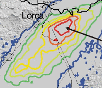
Annual land subsidence rates from 1992 to 2007
The research was carried out by the CIE Campus Moncloa , by researchers of CSIC and the UCM , José Fernández Torres and Pablo José González Méndez, by studying satellite radar data from European Space Agency.
Research has shown for the first time that the land subsidence due to groundwater extraction is a transitory process and non-linear by drought periods. They estimate a sink rate of up to 15 cm per year in the basin of Lorca (Murcia), the highest rate in Europe.
The basin of the river Guadalentín, where Puerto Lumbreras, Lorca, and Alhama de Murcia are, is a very fertile meadow and during the last decades the basin developed a strong agricultural sector. However, water demand for the continued cultivation of land increased rapidly, but the area is a semiarid region with limited water resources. Therefore, they have been extracted underground water resources to keep going the activity since the sixties.
They found that the exploitation of underground water is highly superior to the natural recharge (rainwater infiltration and irrigation returns). This caused a steady decline of groundwater reserves in recent years. The drop in reserves transforms the materials of the aquifer due to a lower internal pressure making them more compact and less volume. This loss generates a surface subsidence of the land.
The process of the surface subsidence on aquifers is well-known from previous researches, though they did not know the current status in the basin of Lorca. However, it has been surprising to find land subsidence rates between 6 and 15 cm per year, this rate turns Lorca into the area where the sinking of the surface is the fastest in the world.
Another relevant aspect is that the level of temporal analysis of data reveals that the land subsidence rates were not constant throughout the period. Therefore, after the droughts between 1992 and 1995 the land responded with an acceleration rate of subsidence, reaching over 15 cm per year between 1996 and 1997. This phase of acceleration occurred in a short period of time, followed by an exponential deceleration that lasted 8 years, after all these years, the subsidence rates recorded back the value registered initially (1992-1995).
Subsidence values have been measured by using 51 images of the area. The RS and ENVISAT satellites of the European Space Agency have provided these images. They applied a technique called ”œdifferential radar interferometry” that establishes slight delays or advances produced on radar waves sent and received from a satellite at two different times. These differential delays produce a standard interference which is proportional to the distance between the satellite and the land. Therefore, they can determine topographic changes with millimetre resolution and its evolution.
The results reveal useful information to determinate de mechanic behaviour of the aquifer. Therefore, when they know the application of external stimulant (drought period) and the time needed for the aquifer to adapt to it, they can determinate hydraulic characteristics, drainage conditions and fluid flow of the aquifer. The transitory deformation (8 years) indicates high compressibility and high hydraulic conductivity and a significant thickness of compressible material.
Nowadays, these researchers and their team are studying in depth the results through two areas of research:
1. Researchers along with the Geological and Mining Institute of Spain and the Universidad de Alicante are studying the mechanical characterization in a laboratory, in addition to use computer simulations. A new research in this area could improve the management of water resources and to characterize geotechnical properties with applications in building security.
2. Researchers are studying the seismic series that happened in Lorca earthquake last May and the modelling used to characterize soil mechanics in collaboration with Professor Kristy F. Tiampo of the University of Western Ontario of Canada and of researchers from the Istituto Nazionale di Geofisica e Vulcanologia of Italy. This area will reveal in detail the process of rupture and seismic energy release.
Spanish audio new at RNE5:
Tag: General Affairs Source: CEI Campus Moncloa
Event date:
26/10/2011
